| | UK Weather Forecasts, Reports and Discussion, June. |  |
|
+4pulse1 jp Mark Hamilton Wazza 8 posters |
|
| Author | Message |
|---|
Wazza
Admin

Posts : 506
Hi-Five : 4
Join date : 2010-04-12
Age : 41
Location : Milton Keynes, UK
 |  Subject: UK Weather Forecasts, Reports and Discussion, June. Subject: UK Weather Forecasts, Reports and Discussion, June.  Tue Jun 22, 2010 8:00 pm Tue Jun 22, 2010 8:00 pm | |
| I hear roumours of storms later in the week? Going to check this out.
Report issued by NetWeather.tv
"For many of us it's another glorious start to the day today, as the spell of settled weather continues, but it's not the same for everyone with some showery rain and extra cloud moving into Northwest Britain from time to time over the coming days.
Today, showers should be few and far between and only affecting parts of Scotland and Ireland, there will be some thicker cloud drifting in though, this even affecting northwest England at times and as a result the temperatures here may be a little down on what we've seen in recent days. Elsewhere though, expect some long sunny spells and temperatures reaching the low to mid twenties again.
Into tomorrow it's a very similar story for much of England and Wales but there will be some extra showers running into Scotland and Ireland, with the odd one perhaps also moving down into Northern England.
Looking ahead to the remainder of the week, the pattern persists - so those heading off to Wimbledon should make sure they take some sunscreen!
If you're wonder when the end to the settled, warm spell may arrive - well it could well be during the weekend and there's a threat that when the breakdown comes it may be with a bang.. " | |
|
 | |
Wazza
Admin
Posts : 506
Hi-Five : 4
Join date : 2010-04-12
Age : 41
Location : Milton Keynes, UK
| | Subject: Re: UK Weather Forecasts, Reports and Discussion, June. Tue Jun 22, 2010 8:14 pm | |
| Just had a quick peek, the weekend, latter part of would be more favourable for anything as the winds then swing round to a S/SW direction, bringing in that moisture. Temps are set to rise, precip is forecast over the weekend. Very early as yet but the set-ups are becoming better with winds/temps & moisture. Numbers are not looking overly brilliant at the moment, but CAPE and LI are around 800 and -2 for Sunday PM, over the Midlands northwards. These images below are to show the High being pushed East and a Low in the Atlantic swinging in a cold front for the weekend. Still early but we will see if any changes do come as the week progresses.   | |
|
| | |
Mark Hamilton

Posts : 107
Hi-Five : 3
Join date : 2010-05-03
Age : 39
Location : St Neots
| | Subject: Re: UK Weather Forecasts, Reports and Discussion, June. Thu Jun 24, 2010 7:30 am | |
| its been a totally gloreous day here in cambridgeshire...highs of 26!
trying to get on here as much as i can but the laptop has had a fit again and is playing up and still no replacement...
i see the next couple of weeks are supposed to be nice aswell...and possible storms to the end of the week? | |
|
| | |
jp
Moderator

Posts : 136
Hi-Five : 1
Join date : 2010-04-26
Location : sunderland, uk
| | Subject: Re: UK Weather Forecasts, Reports and Discussion, June. Thu Jun 24, 2010 8:27 am | |
| just had a quick skoot over the GFS for sat/sun and OMG!! 2000+ CAPE and LI-7!! for the bristol area and midlands all being supported with a S/SW wind and approaching cold front as wazza mentioned. sat is not quiet as exciting but still holds some hope. looks like its time to maybe get excited  | |
|
| | |
Wazza
Admin
Posts : 506
Hi-Five : 4
Join date : 2010-04-12
Age : 41
Location : Milton Keynes, UK
| | Subject: Re: UK Weather Forecasts, Reports and Discussion, June. Thu Jun 24, 2010 10:15 am | |
| Oh yes JP!
Looks like temps are still rising and guess who is off the weekend? Me! But I have to be up at 03:45 monday morning so hoping that cold front arrives sat instead! | |
|
| | |
pulse1
Moderator

Posts : 98
Hi-Five : 2
Join date : 2010-04-12
Age : 62
Location : Darwin, Northern Territory Australia
| | Subject: Re: UK Weather Forecasts, Reports and Discussion, June. Fri Jun 25, 2010 5:14 pm | |
| Nice low there guys. Keep us posted as this thing gets closer! | |
|
| | |
Updraft
Admin

Posts : 352
Hi-Five : 6
Join date : 2010-04-12
Age : 58
Location : Somerset, UK
| | Subject: Re: UK Weather Forecasts, Reports and Discussion, June. Fri Jun 25, 2010 8:42 pm | |
| Without wanting to be the doom and gloom merchant again i cant see much happening this weekend in the way of T/Storms. Certainly not a widespread breakdown with only limited chances for a few areas of the UK. Whilst there is the Low pressure system close by it will not make it far enough E and will also weaken signifigantly during the weekend. At the same time another ridge of High will also start pushing in from the S/SW bringing a more stable airmass and keeping thIs Low to the far W/NW. Saturday SLP 15.00.... 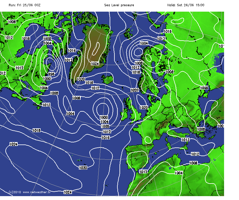 Shows a weak front pushing into more N/NW areas which at this time will certainly look the more favourable areas for anything during Saturday. As ive mentioned things stay out to the W and do weaken as illustrated here in the SLP for 15.00 Sunday. Again still maybe giving the highest chances to areas further N and W. You can also see the signs of another ridge of High pushing in from the SW.  I will add a quick Wind graphic as well here for Sunday 15.00 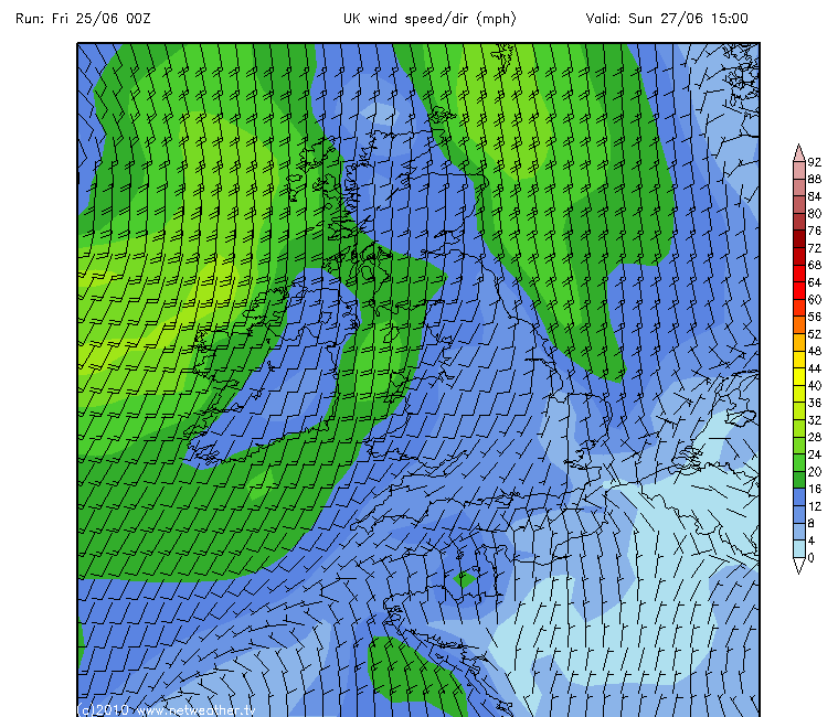 And if i take that another 6 hours forward the High is then making good progress and the Low is now pushed even further N/NW. 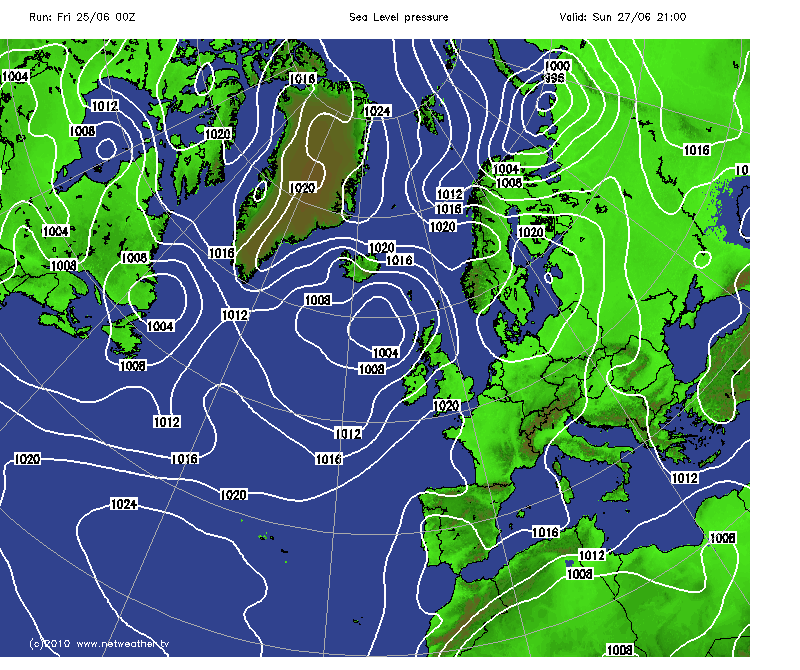 Parts of the UK do show reasonble CAPE and LI during these time frames but without an active system there our chances look limited. As ever scattered heavy showers are likely but the much hoped for T/Storms look unlikely to me generally. Favoured areas to me look like parts of northern Wales, and anywhere on the more western side of the country further north from there with maybe some more central areas included as well. And all of these areas are the ones where things can interact with the Low. Elsewhere it just doesnt look likely at this point in time. This is based on the 00z run 25/06. As ever the next Run may show some subtle changes. | |
|
| | |
jp
Moderator
Posts : 136
Hi-Five : 1
Join date : 2010-04-26
Location : sunderland, uk
| | Subject: Re: UK Weather Forecasts, Reports and Discussion, June. Fri Jun 25, 2010 8:47 pm | |
| sunday still looks to be the day of reckoning but the values have dropped right off and the cold front associated with the approaching low pressure system is weakining. theres still hope tho.
http://www.metoffice.gov.uk/weather/uk/surface_pressure.html
saturday, looks as if the west has the best shout then sunday for the east.
if anything kicks off here i'll set the live stream away at www.severestudios.com | |
|
| | |
jp
Moderator
Posts : 136
Hi-Five : 1
Join date : 2010-04-26
Location : sunderland, uk
| | Subject: Re: UK Weather Forecasts, Reports and Discussion, June. Fri Jun 25, 2010 9:03 pm | |
| | |
|
| | |
Updraft
Admin
Posts : 352
Hi-Five : 6
Join date : 2010-04-12
Age : 58
Location : Somerset, UK
| | Subject: Re: UK Weather Forecasts, Reports and Discussion, June. Fri Jun 25, 2010 9:18 pm | |
| And there i was just gonna answer your PM but theres no need to now is there  As youve probably read im not overly excited for the weekend, but then thats not unusual is it, Mr Doom and Gloom as i should be called most of the time  Yes there are possibilities of a little something but that Low weakens too much and stays too far West. Keep checking those GFS Runs and things will shape up later today as to just what may happen. Cheers, The Grim Reaper  | |
|
| | |
jp
Moderator
Posts : 136
Hi-Five : 1
Join date : 2010-04-26
Location : sunderland, uk
| | Subject: Re: UK Weather Forecasts, Reports and Discussion, June. Fri Jun 25, 2010 10:11 pm | |
| dear weather gods, please send some storms to the SW to cheer up mr grumpy arse down there  i know the feeling mate, maybe the best way is to be grumpy then get a nice suprise clever bugger eh? i've never noticed the tabs up the top before  | |
|
| | |
Updraft
Admin
Posts : 352
Hi-Five : 6
Join date : 2010-04-12
Age : 58
Location : Somerset, UK
| | Subject: Re: UK Weather Forecasts, Reports and Discussion, June. Fri Jun 25, 2010 10:38 pm | |
| Yep i am still wearing my Grumpy Trousers here, been on all spring so far  Been not far from hopeless down this way. Im still prepared to travel if the set up looks as if things are more likely than not but to drive 100 mile plus for a few brief weak storms just isnt worth the time and expense is it. Need one of those big Spanish Plumes arriving on our shores, nailed on action then surely. Oh and thanks for putting the word out about the site as well. Its been a struggle so far and anything on that front will really help, nice one JP  | |
|
| | |
jp
Moderator
Posts : 136
Hi-Five : 1
Join date : 2010-04-26
Location : sunderland, uk
| | Subject: Re: UK Weather Forecasts, Reports and Discussion, June. Fri Jun 25, 2010 11:04 pm | |
| think i must have them on too mate. dont know why i keep getting excited so far out? must be the thought of maybe finally getting what we want. will keep an eye on the next few runs to see what changes. just hope that cold front can keep enough guts  no worries about putting the word out mate. just stuck a post on my FB wall too. | |
|
| | |
Kent Weather

Posts : 47
Hi-Five : 1
Join date : 2010-06-25
Age : 40
Location : Kent
| | Subject: Re: UK Weather Forecasts, Reports and Discussion, June. Sat Jun 26, 2010 12:23 am | |
| FAX Charts still suggest a weakening front which is a shame. I do wonder if this High pressure will infact kill off any convective chances and just leave strong CAPE and very decent Li values (even though GFS does overdo both) with no real chance of storms firing | |
|
| | |
Updraft
Admin
Posts : 352
Hi-Five : 6
Join date : 2010-04-12
Age : 58
Location : Somerset, UK
| | Subject: Re: UK Weather Forecasts, Reports and Discussion, June. Sat Jun 26, 2010 12:55 am | |
| Just about bang on with my line of thinking there.
Im really struggling to see anything of note this weekend.
Low will be too weak, too far west and high pressure holding it back.
But then i sit here typing this looking at a NEW UKASF watch to the right of this screen on the front page.
Need to check that out and see what they are thinking on this one.
Great to see you straight into the discussions as well ! | |
|
| | |
Updraft
Admin
Posts : 352
Hi-Five : 6
Join date : 2010-04-12
Age : 58
Location : Somerset, UK
| | Subject: Re: UK Weather Forecasts, Reports and Discussion, June. Sat Jun 26, 2010 12:59 am | |
| Taken from the UKASF watch recently issued...
Storm Forecast Issued: 2010-06-25 13:27:00
Valid: 2010-06-26 00:00:00 - 2010-06-26 23:59:00
Regions Affected
NW England, W/N Midlands, E Wales and W Northern Ireland (C/S Scotland, N England, Midlands, Wales and Northern Ireland are included in the WATCH)
Synopsis
Low pressure "Ilse" approaches the United Kingdom from the North Atlantic on Saturday, whilst High pressure "Xerxes" remains firmly situated over the North Sea.
Ahead of an increasingly weak eastward-moving cold front, a convergence line is forecast to develop in a N-S direction from the Bristol Channel northwards to southern Scotland. Along this line, aided by local sea breeze effects, scattered showers and thunderstorms are expected to develop. There is a slight risk of a convergence-type funnel. Showers will persist in some areas until the end of this forecast period.
Across Northern Ireland/Ireland, scattered showers and thunderstorms are forecast to develop in the post-frontal airmass, moving northwards. These may persist into the night as they drift towards the Hebrides.
Not much of note there to me.
Will open up V5 Radar and Lightning Trackers and keep tabs. | |
|
| | |
jp
Moderator
Posts : 136
Hi-Five : 1
Join date : 2010-04-26
Location : sunderland, uk
| | Subject: Re: UK Weather Forecasts, Reports and Discussion, June. Sat Jun 26, 2010 1:06 am | |
| seen that too mate. not expecting nothing major but it would just be nice to see one wee storm. its typical tho, we go and buy a DSLR and got cock all to phography storm wise (yet) eagerly awaiting the next run to come out and see what that says | |
|
| | |
Kent Weather
Posts : 47
Hi-Five : 1
Join date : 2010-06-25
Age : 40
Location : Kent
| | Subject: Re: UK Weather Forecasts, Reports and Discussion, June. Sat Jun 26, 2010 1:07 am | |
| Based on that forecast then and for the areas involved, 2 words spring to mind
orographic lifting | |
|
| | |
jp
Moderator
Posts : 136
Hi-Five : 1
Join date : 2010-04-26
Location : sunderland, uk
| | Subject: Re: UK Weather Forecasts, Reports and Discussion, June. Sat Jun 26, 2010 1:31 am | |
| gotta love a bit of convergance. i can defo feel a storm dance coming on, just to try and help things along a touch be interesting to see if estofex and netweather issue a convective watch tomorrow or later today  | |
|
| | |
Updraft
Admin
Posts : 352
Hi-Five : 6
Join date : 2010-04-12
Age : 58
Location : Somerset, UK
| | Subject: Re: UK Weather Forecasts, Reports and Discussion, June. Sat Jun 26, 2010 1:36 am | |
| Low coming onto the coastal regions and then forcing air up as it does so thus maybe something forming along that front/line.
Obviously mentioning the convergance there seems to be the case.
Currently a very small area of small but heavy showers showing in the far SE reaches of Ireland but other than that nothing as yet.
Will have a look at a SAT image as well in a minute. | |
|
| | |
Updraft
Admin
Posts : 352
Hi-Five : 6
Join date : 2010-04-12
Age : 58
Location : Somerset, UK
| | Subject: Re: UK Weather Forecasts, Reports and Discussion, June. Sat Jun 26, 2010 1:43 am | |
| Latest SAT image.... 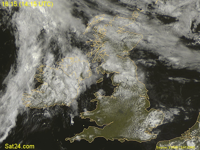 Showing a front now pushing in from the far West. As ive been doing this the latest radar image shows a much more active area of showers pepping up off the West coast of Ireland now. They are just about visible on this sat image literally off the far West coast of Ireland. | |
|
| | |
jp
Moderator
Posts : 136
Hi-Five : 1
Join date : 2010-04-26
Location : sunderland, uk
| | Subject: Re: UK Weather Forecasts, Reports and Discussion, June. Sat Jun 26, 2010 1:44 am | |
| looks like the cold front has come ashore in SW ireland. it does look weak tho and producing the showers ahead of it in SE ireland. need some of that wet stuff here coz the ground is dry as a bone and my veggies dont like it  | |
|
| | |
Updraft
Admin
Posts : 352
Hi-Five : 6
Join date : 2010-04-12
Age : 58
Location : Somerset, UK
| | Subject: Re: UK Weather Forecasts, Reports and Discussion, June. Sat Jun 26, 2010 1:55 am | |
| Why did you have to bring your veggies into in JP You or I , well all of us come to that can buy our spuds and carrots in Asda but we sure as hell cant buy a T/Storm can we !! But having said that a storm will make us all happy, and that includes your veggies...WIN - WIN  Netweather radar seems to be a little confused at the moment with what i would call anomalies between each update. The area off Ireland wasnt there, then looked good and has now all but gone again, in 20 mins as well ! Anyway, all eyes on whats happening from here on in. Netweather currently have no Watches/Alerts issued. PS, i hope your spuds get better soon JP  | |
|
| | |
jp
Moderator
Posts : 136
Hi-Five : 1
Join date : 2010-04-26
Location : sunderland, uk
| | Subject: Re: UK Weather Forecasts, Reports and Discussion, June. Sat Jun 26, 2010 2:15 am | |
| hehehe, been out every night with the watering can trying to make my veggies grow some more cant beat a bit of homegrown. poor radars as confused as us mate, wondering what the hells going on!! think danielle may be going shopping later so i'll ask her to ask in asda if there selling T-storms and if they are, i'll take the lot please, and i'll sell them on to ya for a good price!  wonder what the pub runs gonna come up with?? | |
|
| | |
Updraft
Admin
Posts : 352
Hi-Five : 6
Join date : 2010-04-12
Age : 58
Location : Somerset, UK
| | Subject: Re: UK Weather Forecasts, Reports and Discussion, June. Sat Jun 26, 2010 2:24 am | |
| My other half is out shopping now, back soon hopefully. Not expecting any 3 for 2 offers on T/Storms have been had but failing that i will let her off if there is a case or 2 of beer in there somewhere. Warm weather = Cold Beer. Mike taught me that, never put the 2 together before Oz....he lied  Just checked radar again and im not so sure if they are not having a few issues with it. Hasnt been refreshing as it should and when it does cant see any changes now. Not sure... ? But if it is correct then there really isnt anything happening at all. Must also remind myself that today wasnt really part of what we were looking at and moro and Sun should be the focus. ( but i still dont think anything will happen then either  ) EDIT....and the UKASF Watch is starting at midnight tonight as well. Musnt get too carried away here ! | |
|
| | |
Sponsored content
| | Subject: Re: UK Weather Forecasts, Reports and Discussion, June. | |
| |
|
| | |
| | UK Weather Forecasts, Reports and Discussion, June. | |
|