| | UK Weather Forecasts, Reports and Discussion WC 06/06/10 |  |
|
|
|
| Author | Message |
|---|
Wazza
Admin

Posts : 506
Hi-Five : 4
Join date : 2010-04-12
Age : 41
Location : Milton Keynes, UK
 |  Subject: UK Weather Forecasts, Reports and Discussion WC 06/06/10 Subject: UK Weather Forecasts, Reports and Discussion WC 06/06/10  Tue Jun 08, 2010 9:04 pm Tue Jun 08, 2010 9:04 pm | |
| Some slow moving thundery heavy downpours set to move northwards through today, possibly giving localised flooding in places. This sets a trend for the week, with these showers becoming less frequent as we move through, with signs of drier weather for that all important weekend. But for today, I will be keeping an eye on these showers as they move northwards, hoping to go out and catch something on camera. T/Storm watch issued for the south Midlands by UKASF. Daytime lightning, if any, could be a bit more tricky to capture!!!   
Last edited by Wazza on Wed Jun 09, 2010 9:45 pm; edited 1 time in total | |
|
 | |
Mark Hamilton

Posts : 107
Hi-Five : 3
Join date : 2010-05-03
Age : 39
Location : St Neots
| | Subject: Re: UK Weather Forecasts, Reports and Discussion WC 06/06/10 Tue Jun 08, 2010 10:12 pm | |
| i beleive i am under the very same warning wayne...  its raining heavy to medium all the time at the moment...no sign of any storms yet..but it is quite muggy outside...fed up of getting wet each time i go to my car lol | |
|
| | |
Wazza
Admin
Posts : 506
Hi-Five : 4
Join date : 2010-04-12
Age : 41
Location : Milton Keynes, UK
| | Subject: Re: UK Weather Forecasts, Reports and Discussion WC 06/06/10 Wed Jun 09, 2010 4:05 am | |
| Too right Mark. Couple of pics, and would you believe it, the first pic I took had a nice fork shoot across the cloudbase just as I was setting up, and it was the only strike!!!!!   | |
|
| | |
Mark Hamilton
Posts : 107
Hi-Five : 3
Join date : 2010-05-03
Age : 39
Location : St Neots
| | Subject: Re: UK Weather Forecasts, Reports and Discussion WC 06/06/10 Wed Jun 09, 2010 4:48 am | |
| we have the cell over us RIGHT now...torrential rain and thunder above...got my streaming cam on but its not great....got a video will upload it in a bit.. | |
|
| | |
Wazza
Admin
Posts : 506
Hi-Five : 4
Join date : 2010-04-12
Age : 41
Location : Milton Keynes, UK
| | Subject: Re: UK Weather Forecasts, Reports and Discussion WC 06/06/10 Wed Jun 09, 2010 5:05 am | |
| Cool! If it's a goodun, throw the link here and i'll put it on the front page.  | |
|
| | |
Mark Hamilton
Posts : 107
Hi-Five : 3
Join date : 2010-05-03
Age : 39
Location : St Neots
| | Subject: Re: UK Weather Forecasts, Reports and Discussion WC 06/06/10 Wed Jun 09, 2010 7:08 am | |
| sorry wazza i went straight out with the camera after you posted that! but WOW what a storm....the rain was unreal..will upload my pics in a seperate thread...i got totally soaked lol
roads were completely flooded in st neots....made interesting driving...all passed now..lasted about 1 hour from start to finish | |
|
| | |
Wazza
Admin
Posts : 506
Hi-Five : 4
Join date : 2010-04-12
Age : 41
Location : Milton Keynes, UK
| | Subject: Re: UK Weather Forecasts, Reports and Discussion WC 06/06/10 Wed Jun 09, 2010 9:47 pm | |
| Well today could see the same sorta thing across the Midlands, unfortunately I cannot chase anything as I have work in around an hour. Bugger.  | |
|
| | |
Updraft
Admin

Posts : 352
Hi-Five : 6
Join date : 2010-04-12
Age : 58
Location : Somerset, UK
| | Subject: Re: UK Weather Forecasts, Reports and Discussion WC 06/06/10 Thu Jun 10, 2010 1:30 am | |
| Yet more apologies for the vanishing act the last week or so...just stuff going on and me being me.....  Yesterday was reasonbly interesting here although we didnt actually see a T/Storm. Some really potent showers about for much of the morning and early afternoon but sadly didnt go that extra yard. I was unable to get about and take any pictures but mid-afternoon there were some fantastic cloudscapes on view which really would have made a few decent pics im sure Today sees reasonable CAPE and LI on offer and quite a few slow moving heavy showers with a few showing lightning on trackers within the last hour. Looking at GFS shows most of the UK restricted by CIN so not sure just how many of these showers will give a storm ? Generally the CIN appears to cover all inland areas with things looking far better near the coasts. Although there are a few small pockets that may be okay inland as well. Forecasted to have heavy downpours here today but as yet at 15.30 i have not seen a drop of rain at all.....boring.....but dry ! So now its June 9th and i STILL havent been close to a T/Storm, not a thing. Last year was a struggle but this year is starting to prove VERY testing.....maybe time to sort another trip to Darwin perhaps...thats gonna take some creeping around the wife........  | |
|
| | |
Updraft
Admin
Posts : 352
Hi-Five : 6
Join date : 2010-04-12
Age : 58
Location : Somerset, UK
| | Subject: Re: UK Weather Forecasts, Reports and Discussion WC 06/06/10 Thu Jun 10, 2010 4:23 am | |
| Radars showing lots of potent showers right now with more central regions of the UK having a real soaking by the looks of things. Lightning trackers not showing a lot activity so maybe that Cap is an issue. And as ever...not a thing down this way...not a drop......  Edit...oh and nice pics and vid there as well....makes me feel all the happier in this weather cocoon of mine ! | |
|
| | |
Marianne

Posts : 72
Hi-Five : 2
Join date : 2010-04-16
| | Subject: Re: UK Weather Forecasts, Reports and Discussion WC 06/06/10 Thu Jun 10, 2010 4:36 am | |
| Ooh lightning tracker is showing some lightning just south of me, near the isle of Arran. I hope it comes my way!  | |
|
| | |
Updraft
Admin
Posts : 352
Hi-Five : 6
Join date : 2010-04-12
Age : 58
Location : Somerset, UK
| | Subject: Re: UK Weather Forecasts, Reports and Discussion WC 06/06/10 Thu Jun 10, 2010 4:38 am | |
| Maybe easing off just a touch now but still looking ok for some....  | |
|
| | |
Marianne
Posts : 72
Hi-Five : 2
Join date : 2010-04-16
| | Subject: Re: UK Weather Forecasts, Reports and Discussion WC 06/06/10 Thu Jun 10, 2010 4:49 am | |
| Yeah it's moving away from me. At least I got two flashes and two rumbles on monday around 3pm....so pathetic haha! | |
|
| | |
Updraft
Admin
Posts : 352
Hi-Five : 6
Join date : 2010-04-12
Age : 58
Location : Somerset, UK
| | Subject: Re: UK Weather Forecasts, Reports and Discussion WC 06/06/10 Thu Jun 10, 2010 5:03 am | |
| Last 24 hrs lightning, not a great deal really..... 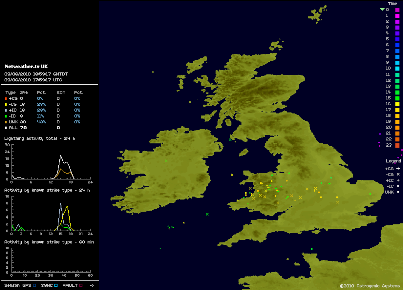 | |
|
| | |
Wazza
Admin
Posts : 506
Hi-Five : 4
Join date : 2010-04-12
Age : 41
Location : Milton Keynes, UK
| | Subject: Re: UK Weather Forecasts, Reports and Discussion WC 06/06/10 Thu Jun 10, 2010 5:08 am | |
| Glad to see we're keeping an eye on things!
Live from the Midlands, well not a lot really... These showers are light, not even heavy, so the cap will be an issue then. Plenty of towering cumulous, few pileus too, so all nice to look at.
This sort of time last year I was off to Brighton I think, chasing something that was a little bigger! | |
|
| | |
Updraft
Admin
Posts : 352
Hi-Five : 6
Join date : 2010-04-12
Age : 58
Location : Somerset, UK
| | Subject: Re: UK Weather Forecasts, Reports and Discussion WC 06/06/10 Thu Jun 10, 2010 5:19 am | |
| Jeez was that a year ago.....  How time flies when youre (not) having fun eh ! Kims just gone out to darts and theres a nice little area bearing down on me here, looking very nice on radar as well, gonna get rather wet very soon i think, currently just making its way over the Blackdown Hills, yes thats up and over where that rod is Wazza. Getting dark rather quickly as i type, dunno if i will get a decent shot sat here at home but will see if i can. As far as whats happened today, very impressive radar returns for most of the afternoon and even now in some areas, numbers did look ok but from my understanding of the CIN on GFS it did appear that full blown T/Storms may have been an issue. Although if Pileaus is on show then those areas are certainly reaching high up into the atmosphere. And its now raining...rather heavily.....radar showing this area just reaching me so i think it should get heavier still. Im off upstairs to hang outta window  Edit....umm yeah it rained and things got wet outside...few structure pics taken from upstairs, will have a look and see how they look on Picassa. Getting that desperate im taking pics of cloudss now  | |
|
| | |
Updraft
Admin
Posts : 352
Hi-Five : 6
Join date : 2010-04-12
Age : 58
Location : Somerset, UK
| | Subject: Re: UK Weather Forecasts, Reports and Discussion WC 06/06/10 Thu Jun 10, 2010 8:39 am | |
| Hmm...Thurs night/Fri morn along the South Coast..... may prove interesting ? BBC weather just showed a LOT of heavy precip so whats there with it ....need to check me thinks  | |
|
| | |
Updraft
Admin
Posts : 352
Hi-Five : 6
Join date : 2010-04-12
Age : 58
Location : Somerset, UK
| | Subject: Re: UK Weather Forecasts, Reports and Discussion WC 06/06/10 Thu Jun 10, 2010 8:48 am | |
| Didnt need to look too hard on that one. Heavy rain and........heavy rain.... | |
|
| | |
Wazza
Admin
Posts : 506
Hi-Five : 4
Join date : 2010-04-12
Age : 41
Location : Milton Keynes, UK
| | Subject: Re: UK Weather Forecasts, Reports and Discussion WC 06/06/10 Thu Jun 10, 2010 9:06 am | |
| Hehe! The towering rod hills? Glad you saw something finally Upps, even though it was small. That's all I've seen today. I saw the watch for heavy rain, was looking at that too a little bit. Don't get that cam wet now will you mate! 
Last edited by Wazza on Thu Jun 10, 2010 9:14 am; edited 1 time in total | |
|
| | |
Updraft
Admin
Posts : 352
Hi-Five : 6
Join date : 2010-04-12
Age : 58
Location : Somerset, UK
| | Subject: Re: UK Weather Forecasts, Reports and Discussion WC 06/06/10 Thu Jun 10, 2010 9:12 am | |
| Hehe, me get a camera wet on the coast.....again...maybe.
Read on , look out for Doris !
Synopsis
Low pressure "Doris" is located over Biscay on Thursday, dominating the weather across the United Kingdom.
A warm and humid airmass is advected northwestwards around the eastern and northern flank of the system. Destabilisation of this airmass is expected to occur over France and the Low Countries, with scattered thunderstorms developing, with a threat of tornadoes.
Whilst the weather is forecast to be thunderstorm-free across most, if not all, of the United Kingdom, it is possible that the triple point of Low pressure "Doris" may contain some convective elements, which moves northwards into the English Channel during the evening, approaching Kent/Sussex at the very end of this forecast period. This remains uncertain, but there is a threat of embedded thunderstorms within the rainband moving slowly north across the Channel during the evening hours. We will monitor this developing situation during Thursday. | |
|
| | |
Wazza
Admin
Posts : 506
Hi-Five : 4
Join date : 2010-04-12
Age : 41
Location : Milton Keynes, UK
| | Subject: Re: UK Weather Forecasts, Reports and Discussion WC 06/06/10 Thu Jun 10, 2010 9:16 am | |
| OOhhh how exciting! Good ol Doris!
Work for me till 22:00, but that still gives me enough time to have a peek after work. Off to check GFS etc.... | |
|
| | |
Updraft
Admin
Posts : 352
Hi-Five : 6
Join date : 2010-04-12
Age : 58
Location : Somerset, UK
| | Subject: Re: UK Weather Forecasts, Reports and Discussion WC 06/06/10 Thu Jun 10, 2010 9:20 am | |
| I will add to the above and i know its something that weve commented on many times before..... i just dont understand why France which is certainly close to the UK seems to get totally different set ups from here in the UK ? From what ive seen so far this spring we are no more than a couple 100 miles from a LOT of weather and that trend seems to carry on week in week out. Looking at this system just over the channel yet again Cape and LI is way and above what we will see here and of course the chances of storms and yes even a few nados continue to signifigantly higher. Really does get to me.....  Ok rant over....  | |
|
| | |
Wazza
Admin
Posts : 506
Hi-Five : 4
Join date : 2010-04-12
Age : 41
Location : Milton Keynes, UK
| | Subject: Re: UK Weather Forecasts, Reports and Discussion WC 06/06/10 Thu Jun 10, 2010 9:23 am | |
| Deffo - Land mass and English Channel seem to be the probs here.
Just looked at the GFS and saw the nice numbers on the northern French coast - wind values at 500 are pushing directly northwards towards the south coast of the UK. So any developed storms over northern France i'd expect to blow towards the UK coastline. So if it does fire up then the south coast could be a nice place to be over tomorrow night! | |
|
| | |
Updraft
Admin
Posts : 352
Hi-Five : 6
Join date : 2010-04-12
Age : 58
Location : Somerset, UK
| | Subject: Re: UK Weather Forecasts, Reports and Discussion WC 06/06/10 Fri Jun 11, 2010 12:10 am | |
| Looks as if my plans for a few hours on the South Coast after a storm or two are over before they were even started..... GFS and forecasts still showing this area of thundery rain making its way into the UK but it now appears to be more an early morning event with the SE/Kent looking quite favourable for some T/Storms. Rainfall totals could well reach 30mm as well. Will keep tabs just in case something does change but for me thats way way to far to go ! Oh i hate the weather  | |
|
| | |
Updraft
Admin
Posts : 352
Hi-Five : 6
Join date : 2010-04-12
Age : 58
Location : Somerset, UK
| | Subject: Re: UK Weather Forecasts, Reports and Discussion WC 06/06/10 Fri Jun 11, 2010 12:18 am | |
| As yet no change to the UKASF watch and no Alerts/Watches issued by Netweatheruk. Come on please change it, not asking much really, only 200 miles further West and maybe 10 hours earlier And yet again France looks so good for T/Storms  | |
|
| | |
Wazza
Admin
Posts : 506
Hi-Five : 4
Join date : 2010-04-12
Age : 41
Location : Milton Keynes, UK
| | Subject: Re: UK Weather Forecasts, Reports and Discussion WC 06/06/10 Fri Jun 11, 2010 9:42 am | |
| Right that's it. I'm buying a boat! Lol
France us seeing it's fair share for sure. All died off now by the looks. | |
|
| | |
Sponsored content
| | Subject: Re: UK Weather Forecasts, Reports and Discussion WC 06/06/10 | |
| |
|
| | |
| | UK Weather Forecasts, Reports and Discussion WC 06/06/10 | |
|