| | UK Weather Forecasts, Reports and Discussion 26/04/10 |  |
|
|
|
| Author | Message |
|---|
Updraft
Admin

Posts : 352
Hi-Five : 6
Join date : 2010-04-12
Age : 58
Location : Somerset, UK
 |  Subject: UK Weather Forecasts, Reports and Discussion 26/04/10 Subject: UK Weather Forecasts, Reports and Discussion 26/04/10  Mon Apr 26, 2010 9:18 pm Mon Apr 26, 2010 9:18 pm | |
| So into another week, will get the thread up so feel free to add as you wish.
I will get some grahpics up later today but for now just a very brief comment on how things look at the moment.
Temps look to be on the increase again this week with something in the region of 22-23C in the SE/E during Weds. Elsewhere mid-high teens seem quite likely.
It does look as if an Atlantic system will affect parts of the more NW regions of the UK with some heavy and persistant rainfall likely.
Will get more detail up later today as i say but not looking too bad for the coming week.
Maybe those raised temps will get a storm or two on the go...heres hoping.
Oh and maybe a few heavy showers in the S/SE a little later today as well, a rumble or two as well....? | |
|
 | |
Wazza
Admin

Posts : 506
Hi-Five : 4
Join date : 2010-04-12
Age : 41
Location : Milton Keynes, UK
| | Subject: Re: UK Weather Forecasts, Reports and Discussion 26/04/10 Tue Apr 27, 2010 2:37 am | |
| Nice one Upps.  Looking like it will be another warm one this week, too much cloud cover today for my liking but hopefully the rest of the week will be better. | |
|
| | |
Updraft
Admin
Posts : 352
Hi-Five : 6
Join date : 2010-04-12
Age : 58
Location : Somerset, UK
| | Subject: Re: UK Weather Forecasts, Reports and Discussion 26/04/10 Tue Apr 27, 2010 4:47 am | |
| NOT HAPPY  Just spent 20 minutes typing out the mini forecast, was adding the graphics and lost the whole lot.....  Will take 5, calm down, compose myself and start all over again. | |
|
| | |
jp
Moderator

Posts : 136
Hi-Five : 1
Join date : 2010-04-26
Location : sunderland, uk
| | Subject: Re: UK Weather Forecasts, Reports and Discussion 26/04/10 Tue Apr 27, 2010 5:10 am | |
| deep breaths mate......in.........out.......in.......out   i had a quick flick earlier and temps are defo on the up but i might get a drop of the wet stuff on wed. had a beautiful first half of the morning the the cloud arrived, but still warm tho. | |
|
| | |
Updraft
Admin
Posts : 352
Hi-Five : 6
Join date : 2010-04-12
Age : 58
Location : Somerset, UK
| | Subject: Re: UK Weather Forecasts, Reports and Discussion 26/04/10 Tue Apr 27, 2010 7:14 am | |
| So still just a tad annoyed i will try again, this time keeping my fingers away from the "esc" button on the keyboard ! Looking to be another reasonbly quiet week weather wise with little of note again and little if any chances of a storm anywhere. The UK is currently sat nicely under a High which is giving us these settled conditions and will see temps slowly rise up to and including Weds. However there is a Low which will start to push in from the West and affect more N/NW regions of the UK/Scot during Tues. Looking at a broad range of temps UK wide with things far cooler in the N due to the cooler airflow arriving with the Low. Also looking at some heavy rain for those N/NW regions during Tues/Weds. Temp wise, Tues 12-19C and Weds 9-21C with much of the Southern half of the country enjoying plenty of sunshine after any early mist and low cloud clears. Into Thurs we lose the controlling High and weak fronts will push across much of the country with light rain possible and temps falling slightly, ranging from 10-17C. Things change only slightly into Friday with temps dropping a little further, 5-16C and again some rain possible in many areas. Into the weekend temps continue to drop a litte with highs currently looking to be in the 12C region. By this time there will be a well defined N/NE airflow over the country and temps reflect that well. During Sat any rain should be confined to Southern areas and Sunday looks to be dry at the moment. Not forgetting that this weekend is a Bank Holiday so you wouldnt really expect things to be warm and sunny would you ! Will post up a few grahics just to give some detail but nothing much of note as ive already mentioned..... All Graphics courtesy of Netweather.tv SLP Tues 12.00 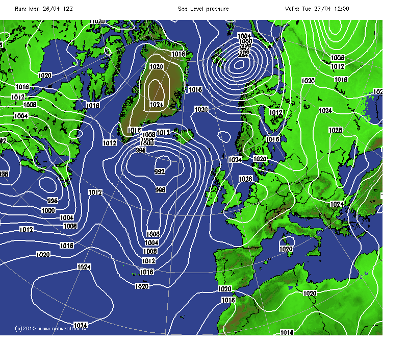 SLP Thurs 12.00 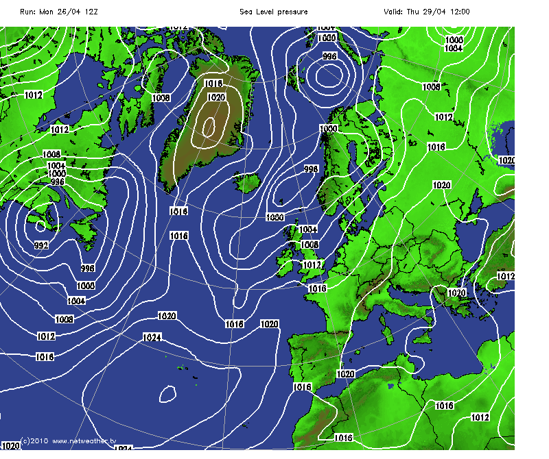 SLP Sat 12.00 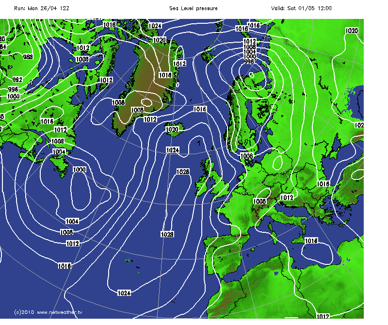 And Wind Speed/DIrection which shows how the warm airflow on Weds changes to a much cooler airflow into Sat. Weds 12.00 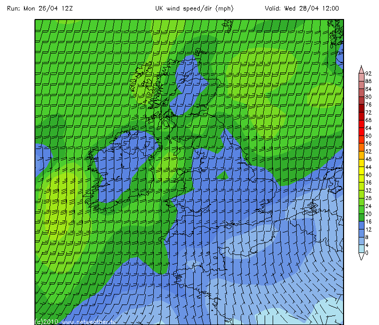 Sat 12.00 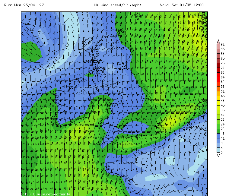 And just for amusement only, the best i could find for CAPE and LI during the week. And if you looking Mike promise me you didnt laugh... 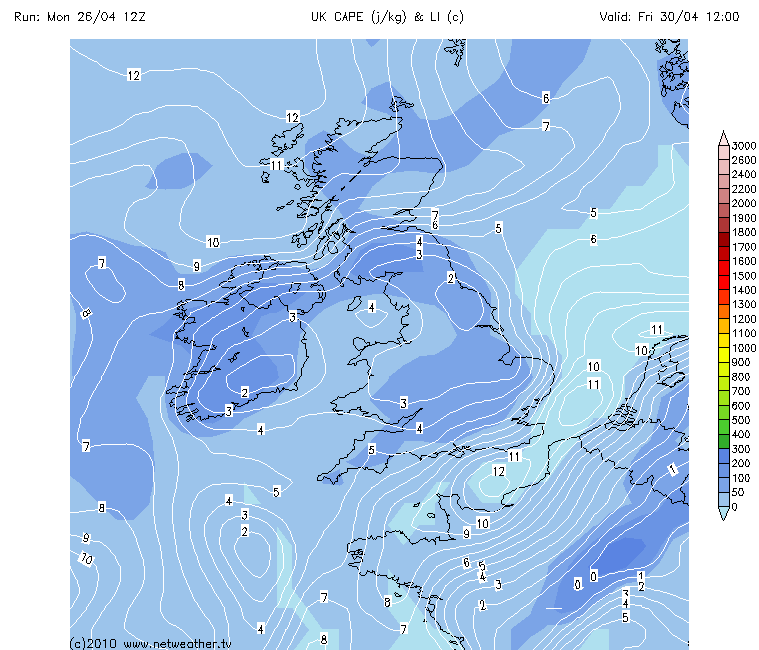 Thats about it as April draws to a close, not a great deal happening so enjoy the sunshine and warmth when its here this week. Heres hoping May brings some more active weather patterns and those T/Storms finally get going. | |
|
| | |
Marianne

Posts : 72
Hi-Five : 2
Join date : 2010-04-16
| | Subject: Re: UK Weather Forecasts, Reports and Discussion 26/04/10 Tue Apr 27, 2010 7:44 am | |
| Thanks Julian, shame about no storms, but can't really complain about some sunshine! | |
|
| | |
Wazza
Admin
Posts : 506
Hi-Five : 4
Join date : 2010-04-12
Age : 41
Location : Milton Keynes, UK
| | Subject: Re: UK Weather Forecasts, Reports and Discussion 26/04/10 Tue Apr 27, 2010 3:50 pm | |
| Whey he got there in the end!
Yes, weekend not looking great, nice comparison with the airflow Upps. Deffo going to make the most of these next few days. You would have hoped the colder air would have gone by now. | |
|
| | |
Updraft
Admin
Posts : 352
Hi-Five : 6
Join date : 2010-04-12
Age : 58
Location : Somerset, UK
| | Subject: Re: UK Weather Forecasts, Reports and Discussion 26/04/10 Wed Apr 28, 2010 5:09 am | |
| A few subtle changes on todays 12z GFS run looking at Thusday.
Now appears to a a larger area of rain which at times could well be quite heavy across much of the S half of the UK around midday into the early evening. Not seeing CAPE and LI there to support any T/Storms at the moment but maybe worth checking just in case a little something is possible. Not looking anything like on this Run I must add.
And again during Friday/Saturday/Sunday maybe a few areas seeing a few heavy showers but numbers not there for the storms. But the downward trend certainly still set and the Bank Holiday weekend isnt looking too encouraging in general.
Last edited by Updraft on Wed Apr 28, 2010 5:23 am; edited 1 time in total | |
|
| | |
Updraft
Admin
Posts : 352
Hi-Five : 6
Join date : 2010-04-12
Age : 58
Location : Somerset, UK
| | Subject: Re: UK Weather Forecasts, Reports and Discussion 26/04/10 Wed Apr 28, 2010 5:09 am | |
| Edit...someone out there is laughing at me Yesterday i lost a whole post and today the above post appeared twice. So obviously edited it out now. Strange  | |
|
| | |
Wazza
Admin
Posts : 506
Hi-Five : 4
Join date : 2010-04-12
Age : 41
Location : Milton Keynes, UK
| | Subject: Re: UK Weather Forecasts, Reports and Discussion 26/04/10 Wed Apr 28, 2010 5:52 am | |
| Hehe you're doing well mate!
It felt very close today, looked at the GFS for stormy stuff but nothing. Keeping an eye on the weekend for sure. | |
|
| | |
Joanna762
Posts : 70
Hi-Five : 0
Join date : 2010-04-12
Location : Jersey, UK
| | Subject: Re: UK Weather Forecasts, Reports and Discussion 26/04/10 Thu Apr 29, 2010 5:13 am | |
| Nice and warm here today, very close in fact too. Wondered if we might get some rumbles tonight but I think we are in for fog and some rain tomorrow, feeling much cooler - the coastal temps might drop too quickly for any thunder! | |
|
| | |
Wazza
Admin
Posts : 506
Hi-Five : 4
Join date : 2010-04-12
Age : 41
Location : Milton Keynes, UK
| | Subject: Re: UK Weather Forecasts, Reports and Discussion 26/04/10 Thu Apr 29, 2010 9:12 pm | |
| I must admit, it was very humid yesterday, and the same for today too! That rain band certainly is beginning to make its presence known now, clouding over as the front pushes in.  Next few days will see rain, Monday looking to be the best of the days so far. Some of this rain will be on the heavy side, so brollies at the ready. Garden needs it to be honest! | |
|
| | |
Updraft
Admin
Posts : 352
Hi-Five : 6
Join date : 2010-04-12
Age : 58
Location : Somerset, UK
| | Subject: Re: UK Weather Forecasts, Reports and Discussion 26/04/10 Fri Apr 30, 2010 3:51 am | |
| Today we have had rain, then some rain and after that some rain fell as well  Nice... | |
|
| | |
Wazza
Admin
Posts : 506
Hi-Five : 4
Join date : 2010-04-12
Age : 41
Location : Milton Keynes, UK
| | Subject: Re: UK Weather Forecasts, Reports and Discussion 26/04/10 Fri Apr 30, 2010 4:06 am | |
| Moist?  | |
|
| | |
Joanna762
Posts : 70
Hi-Five : 0
Join date : 2010-04-12
Location : Jersey, UK
| | Subject: Re: UK Weather Forecasts, Reports and Discussion 26/04/10 Fri Apr 30, 2010 7:10 am | |
| Rubbish !! Winter returned this morning with cold and rain! Summer returned this afternoon, actually hot! Spring came in this evening with cooler and foggy conditions! Wonder what we'll end up with tomorrow! Very confusing! | |
|
| | |
jp
Moderator
Posts : 136
Hi-Five : 1
Join date : 2010-04-26
Location : sunderland, uk
| | Subject: Re: UK Weather Forecasts, Reports and Discussion 26/04/10 Fri Apr 30, 2010 7:36 am | |
| been a peachy day here with temps around 17-19c with sunny intervals. im gonna lock myself in the cupboard tho when this cold rubbish arrives over the weekend.
wonder if el-nino has something to do with it? been odd weather patterns since november! | |
|
| | |
Wazza
Admin
Posts : 506
Hi-Five : 4
Join date : 2010-04-12
Age : 41
Location : Milton Keynes, UK
| |
| | |
Updraft
Admin
Posts : 352
Hi-Five : 6
Join date : 2010-04-12
Age : 58
Location : Somerset, UK
| | Subject: Re: UK Weather Forecasts, Reports and Discussion 26/04/10 Sat May 01, 2010 12:11 am | |
| Valid: 30/04/2010 0600 - 01/05/2010 0600
Headline: ...THERE IS A RISK OF THUNDERSTORMS FORECAST...
Synopsis
An upper trough is forecast to move SE across northern/central UK during Friday. At the surface: a low is centred over Sweden at 12z & will have moved little by 00z Saturday, with a SW flow across southern UK veering W to NW across northern UK then veering N'erly over northern Scotland by 00z as front moves south across Scotland.
... N. IRELAND/REP. of IRELAND, SCOTLAND, WALES and W/CENTRAL/N ENGLAND ...
SE-ward progression of mid-level cold pool aloft across northern/central UK during the day, associated with passage SE of upper trough, will steepen lapse rates aloft as surface heating increases in any sunshine - leading to development of scattered heavy showers and isolated thunderstorms by the afternoon across Ireland, Scotland and parts of England and Wales away from the SE. Lack of vertical/directional shear and fairly cool temperatures will mean severe weather is rather unlikely. Steep lapse rates and drier air moving in aloft from NW will likely see convective cells accompanied by hail, occasional lightning and gusty winds. Wind convergence zone(s) moving SE at the surface means that any strong updrafts could produce a funnel as updrafts are stretched or even an isolated weak tornado. Any storms should quickly die out after nightfall.
Issued by: Nick F - Forecaster for Netweather | |
|
| | |
Marianne
Posts : 72
Hi-Five : 2
Join date : 2010-04-16
| | Subject: Re: UK Weather Forecasts, Reports and Discussion 26/04/10 Sat May 01, 2010 4:51 am | |
| One word - WOW.
Utterly surrounded by anvils, major convection in the works here - even have a small shelf cloud and a wall cloud on a cell.
I've taken pics but I won't be able to share them until Tuesday as I don't have my camera lead!
No thunder or lightning to report yet, although they're still fairely distant. | |
|
| | |
Marianne
Posts : 72
Hi-Five : 2
Join date : 2010-04-16
| | Subject: Re: UK Weather Forecasts, Reports and Discussion 26/04/10 Sat May 01, 2010 7:26 am | |
| I just had the twin (not THIS one, this one is from the Telegraph, from Oklahoma) of this -  Over the hills across from me. ... I can't wait till you guys see it! My eyes popped out of my skull! You could clearly see the whole thing rotating. About an hour after I caught it on camera is started to break up...with a brilliant shelf cloud coming right at me. Still no thunder and lightning yet though! | |
|
| | |
Wazza
Admin
Posts : 506
Hi-Five : 4
Join date : 2010-04-12
Age : 41
Location : Milton Keynes, UK
| | Subject: Re: UK Weather Forecasts, Reports and Discussion 26/04/10 Sat May 01, 2010 6:44 pm | |
| Great stuff Marianne, can't wait for you to get that camera lead, certainly the greatest instability over your area!
For today...
Valid: 30/04/2010 1900 - 02/05/2010 0000
Headline: ...THERE IS A RISK OF THUNDERSTORMS FORECAST...
Synopsis
A cyclonic NW'erly upper flow will affect the UK during Saturday, with a trough digging SW across Ireland with closed upper low moving SE towards SW England during the day. At the surface, developing shallow low over Ireland at midday will move ESE to be centred over SE England by midnight, while occlusion over northern UK moves south introducing a colder northerly flow for Sunday.
... IRELAND, WALES, MIDLANDS, SW and S ENGLAND ...
Showers maybe slow to clear eastern England tonight, but risk of t-storms should rapidly diminish after dark through lack of diurnal heating.
During Saturday morning, mid-level cold pool across Ireland associated with upper low/trough moving SE, will increase instability across Ireland as surface heating in sunshine steepens lapse rates, allowing heavy showers and the odd t-storm to develop by early afternoon. As this colder air aloft spreads further SE across S Wales, and SW, central and southern England, lapse rates will like-wise steepen with diurnal heating with heavy showers quite widely breaking out. Convection over all these areas maybe accompanied by pea-sized hail and gusty winds and also occasional lightning with stronger pockets of instability, though greatest chance of thunderstorms will likely be across Ireland with strongest instability here. Given weak vertical and speed shear, no severe weather is anticipated. Any storms should die out after dark.
Issued by: Nick F - Forecaster for Netweather | |
|
| | |
Updraft
Admin
Posts : 352
Hi-Five : 6
Join date : 2010-04-12
Age : 58
Location : Somerset, UK
| | Subject: Re: UK Weather Forecasts, Reports and Discussion 26/04/10 Sat May 01, 2010 10:57 pm | |
| Sort those pictures out Marianne, looking forward to seeing what was there. Yesterday saw large areas peppered with heavy showers although i didnt see much in the way of T/Storm activity on any of the trackers. Scotland and Ireland certainly had the best of any Instability with little if any further South. Current radar shows heavy showers breaking out in many areas but as yet nothing showing in the way of T/Storms although looking at the warning above there seems to be a reasonable chance of a few as the day wears on as the Instabilty slides further SE from Ireland where it currently sits. GFS shows CAPE of 600 and LI OF -2 there at the moment so favourable for something for sure. Early this morning whilst at work there were numerous nice Updrafts on show with a few showing Pileus as well which certainly made my morning. Something beautiful about Pileus to me. Now seeing things cloud over and some heavy showers breaking out here in the SW. Worhwhile keeping a watch today just in case a few storms do get going  | |
|
| | |
weatherevents.net
Admin

Posts : 152
Hi-Five : 4
Join date : 2010-04-14
Location : Fife, Scotland
| | Subject: Re: UK Weather Forecasts, Reports and Discussion 26/04/10 Sun May 02, 2010 4:47 am | |
| I uploaded yesterday's time-lapse video to youtube just a short while ago, as it contained a nice towering cumulus cloud system developing from about 16:00 onwards over Benarty Hill (the hill visible in the background of the pic). The system eventually produces some convective precip that heads right over our house. Available here for those interested: https://www.youtube.com/watch?v=h6BQ5H0MaII Marianne, holding my breath for your pics from yesterday!  | |
|
| | |
Wazza
Admin
Posts : 506
Hi-Five : 4
Join date : 2010-04-12
Age : 41
Location : Milton Keynes, UK
| | Subject: Re: UK Weather Forecasts, Reports and Discussion 26/04/10 Sun May 02, 2010 5:50 am | |
| I hear Marianne has gone out on the Razz so we may have to wait a bit longer...
Awesome video Graham, love seeing these mate so keep posting. | |
|
| | |
Wazza
Admin
Posts : 506
Hi-Five : 4
Join date : 2010-04-12
Age : 41
Location : Milton Keynes, UK
| | Subject: Re: UK Weather Forecasts, Reports and Discussion 26/04/10 Sun May 02, 2010 7:42 am | |
| Just had small cell bubble up over me producing the odd flash of lightning, managed to get some IC stuff but that was it. Well one shit actually! Will post later. | |
|
| | |
Sponsored content
| | Subject: Re: UK Weather Forecasts, Reports and Discussion 26/04/10 | |
| |
|
| | |
| | UK Weather Forecasts, Reports and Discussion 26/04/10 | |
|