| | UK Weather Forecasts, Reports and Discussion WC 19/04/10 |  |
|
|
|
| Author | Message |
|---|
Updraft
Admin

Posts : 352
Hi-Five : 6
Join date : 2010-04-12
Age : 58
Location : Somerset, UK
 |  Subject: UK Weather Forecasts, Reports and Discussion WC 19/04/10 Subject: UK Weather Forecasts, Reports and Discussion WC 19/04/10  Mon Apr 19, 2010 6:09 pm Mon Apr 19, 2010 6:09 pm | |
| So yet again we start another working week and of course time to get this weeks thread started. Only had a quick glance through GFS so far and appears that things will again be reasonbly settled with little of note likely to happen with High Pressure dominating and temps near average. April has been quite a non-descript month really with little to get excited about weather wise. For me im always looking for those sharp April showers that are always likely to be a bit squally with Hail/Thunder a possibility. Shouldnt complain at what has been generally a warm and settled month i suppose but i guess thats not really what we want is it. Will be posting up an overview of the coming week with a few graphics a little bit later today. As ever please feel free to add anything you can so we can get things rolling along nicely here  | |
|
 | |
Joanna762
Posts : 70
Hi-Five : 0
Join date : 2010-04-12
Location : Jersey, UK
| | Subject: Re: UK Weather Forecasts, Reports and Discussion WC 19/04/10 Mon Apr 19, 2010 8:01 pm | |
| Well, our weather is fine and settled for the time being, 'slack' pressure over the Channel giving us some calmer winds, slight in fact at the moment. A little fog out towards the SW at first but sunny mainly with a little haze. Temps around 17 for today. I'm not complaining! | |
|
| | |
Updraft
Admin
Posts : 352
Hi-Five : 6
Join date : 2010-04-12
Age : 58
Location : Somerset, UK
| | Subject: Re: UK Weather Forecasts, Reports and Discussion WC 19/04/10 Mon Apr 19, 2010 8:25 pm | |
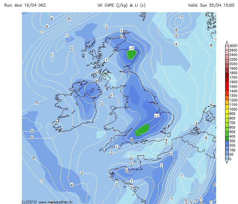
| So here goes for my little stab at what GFS is saying to me for the next 6 days. And as expected things will continue to be quite settled with little changing during the week with temps maybe dropping a little and night-time frosts for many. Seems only right to start with a few Jet Stream graphics with the Volcanic Ash causing travel chaos for much of Europe.I have posted Mon, Tues and Weds here and as you can see the UK will continue to be directly under an airflow bringing this Ash down from Iceland. Even past Weds theres only small changes in direction during Thurs and once into Fri a much more S/SW flow looks likely. ALL GRAPHICS USED COURTESY OF Netweather.tv Mon... 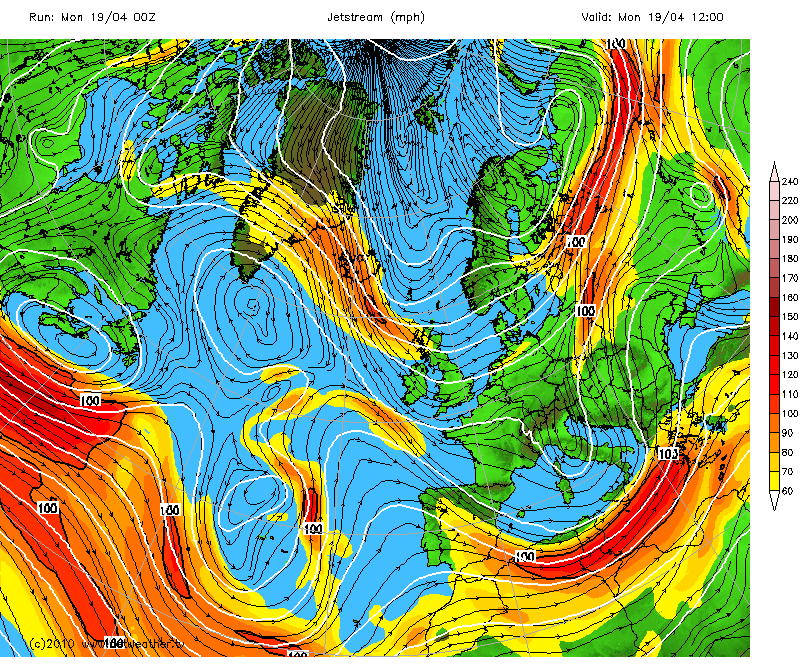 Tues... 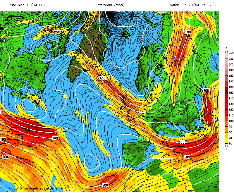 Weds... 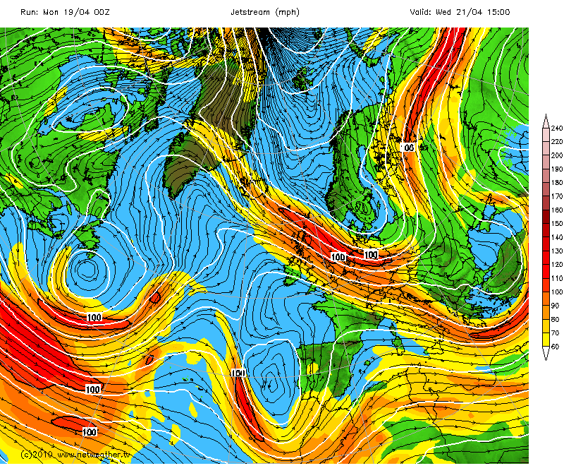 Back to the weather itself, will start with SLP Graphics for Mon,Weds and Friday.... Mon... 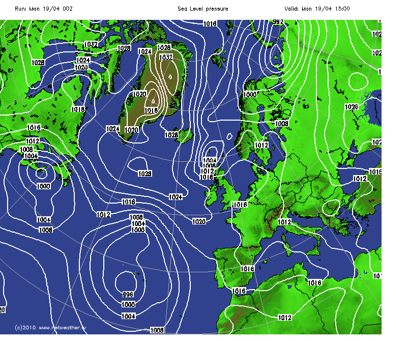 Weds...  Fri... 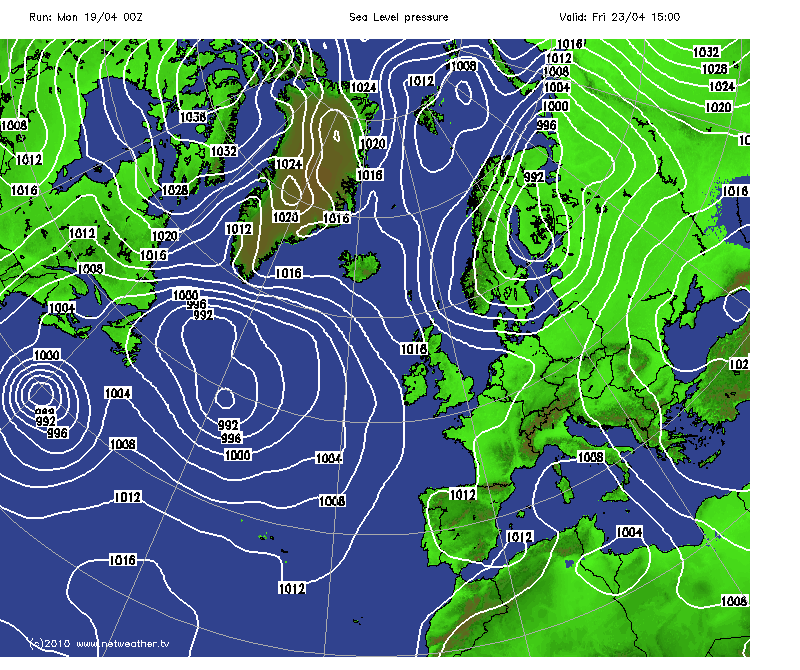 So as you can see looking quite settled throughout with maybe something a little bit more active/interesting arriving late Sat in to Sun. During today temps will again reach 15-16C further S but much cooler further N and lows of maybe 4/5C during the day. There is a front pushing down across the UK with some rain and maybe a few heavier bursts as well. Not looking like there will be any storms as there doesnt seem to be any Instability at all showing. Looking ahead upto and including Friday, daytime temps generally in the 7- 15C range with the N continuing to be cooler with temps as low as 4C in some areas. As the SLP graphics show winds will be light for most and from a more N'erly direction until later in the week when things do change to a milder direction. Precip wise, ive mentioned todays heavy showers, during the rest of the week looks to be light showers possible which will be mainly confined to more N/NE and E regions. Something worth noting is that during the whole week Night-time temps will fall away quickly once the sun has set and the majority of the UK will see frosts, maybe dropping as low as -4 in a few sheltered areas but certainly -1 to -2 very likely. During Sat things look to change with an Atlantic system moving in bringing what GFS currently shows as some heavy rain arriving from the W/SW. This will push across all of the UK overnight with what looks to be some heavy showers behind and some rather nice CAPE and LI numbers as well. Too far out to get excited about as we know but heres a little teaser anyway..... Sun SLP... 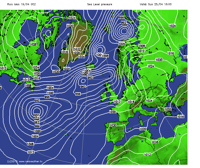 And enough to cause some interest at this point in time maybe ? 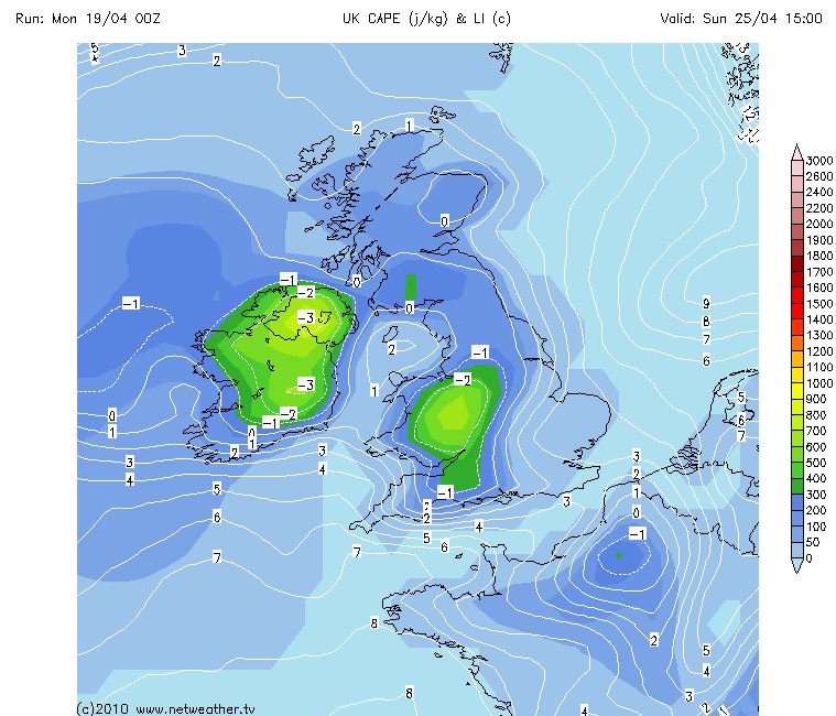 So thats about if for now, not a great deal happening but maybe the weekend could bring something of interest, time will tell. And of course much can change before then anwyay. Julian. | |
|
| | |
pulse1
Moderator

Posts : 98
Hi-Five : 2
Join date : 2010-04-12
Age : 62
Location : Darwin, Northern Territory Australia
| | Subject: Re: UK Weather Forecasts, Reports and Discussion WC 19/04/10 Mon Apr 19, 2010 11:37 pm | |
| Nice addition with the graphics, Julian. At least the ash will be pretty good for the garden if any make it that far south! From the looks of things it's pretty stable in your region for the next part of this week. Even though you've got some instability, it's not a lot given there's regions of stable LI's surrounding you and the southern portion is only -1. Being forever the optimist however, ya just never know...but don't give up your darts night for it! Possibly the weekend may hold something for you if either of those low pressure cells to the west decide to move in across the UK...outer layers aren't that strong but maybe look for some 'waves' from these cells on the sat imagery during mid-week, it might hold some surprises. This may be the reason the cape is there...a warm moist boundary to the east and an incoming low pressure wave/front. Keep an eye on the obs during Friday/Sat to see if anything will trigger some decent lift and perhaps stormvection...  | |
|
| | |
Updraft
Admin
Posts : 352
Hi-Five : 6
Join date : 2010-04-12
Age : 58
Location : Somerset, UK
| | Subject: Re: UK Weather Forecasts, Reports and Discussion WC 19/04/10 Tue Apr 20, 2010 1:49 am | |
| Nice bit of added info there Mike and as im sure you will already know there will be a few of us checking things closely late Fri and certainly during Sat/Sun. Whilst the CAPE and LI is almost pitiful in comparison to what you lucky people in Aus see it would be enough to get something going here, would only be weak given those numbers but seen storms fire in ranges like those shown. As you say SAT images may well help in picking something up as this systems travels across the UK. Saturday still shows heavy rain but very very little instability coupled with it and its only into Sun that things increase and that does appear to be when the main rain bands have cleared through. Knowing things here we will look at the pub-run GFS later and it will show nothing at all  We live in hope  | |
|
| | |
Updraft
Admin
Posts : 352
Hi-Five : 6
Join date : 2010-04-12
Age : 58
Location : Somerset, UK
| | Subject: Re: UK Weather Forecasts, Reports and Discussion WC 19/04/10 Tue Apr 20, 2010 1:51 am | |
| Just a little SAT loop showing the weak front pushing in across the UK.
http://www.sat24.com/gb | |
|
| | |
Updraft
Admin
Posts : 352
Hi-Five : 6
Join date : 2010-04-12
Age : 58
Location : Somerset, UK
| |
| | |
Wazza
Admin

Posts : 506
Hi-Five : 4
Join date : 2010-04-12
Age : 41
Location : Milton Keynes, UK
| | Subject: Re: UK Weather Forecasts, Reports and Discussion WC 19/04/10 Wed Apr 21, 2010 3:43 am | |
| Hmmm that's odd, I looked at Cape and Li and found nothing of any interest! Was I being fuzzy? Will look deeper when I get a mo. | |
|
| | |
Updraft
Admin
Posts : 352
Hi-Five : 6
Join date : 2010-04-12
Age : 58
Location : Somerset, UK
| | Subject: Re: UK Weather Forecasts, Reports and Discussion WC 19/04/10 Wed Apr 21, 2010 4:49 am | |
| Wazza mate latest run showed it as just about all gone...nothing. Since I posted original graphics with every run it has decreased. A sad sight that was as well. Even the precip is now not looking much either. Still possibly some heavier stuff during Sun. Liking the way the temps rise during the day as well, 20C on the cards so maybe that will set off a little something. But certainly need the GFS runs to improve back again towards what was being shown a few days ago  | |
|
| | |
Wazza
Admin
Posts : 506
Hi-Five : 4
Join date : 2010-04-12
Age : 41
Location : Milton Keynes, UK
| | Subject: Re: UK Weather Forecasts, Reports and Discussion WC 19/04/10 Wed Apr 21, 2010 11:02 pm | |
| Ooh quick look and temps are set to rise, quite a lot! Shorts and sandals out I think Monday looking at 23C, nice! | |
|
| | |
Updraft
Admin
Posts : 352
Hi-Five : 6
Join date : 2010-04-12
Age : 58
Location : Somerset, UK
| | Subject: Re: UK Weather Forecasts, Reports and Discussion WC 19/04/10 Thu Apr 22, 2010 4:50 am | |
| Looks like it may be game on again for Sunday ! GFS showing things looking very favourable for a storm or two, certainly the best set of numbers ive seen so far this year. LI up to maybe -4 and CAPE up around the 900-1000 mark in some areas. Other factors to take into consideration of course. Also plenty of heat in there a bit later in the day. Need to keep a eye on things a little nearer the time of course before getting over-excited. Just hope that it doesnt all change..again. Maybe a little  | |
|
| | |
Updraft
Admin
Posts : 352
Hi-Five : 6
Join date : 2010-04-12
Age : 58
Location : Somerset, UK
| | Subject: Re: UK Weather Forecasts, Reports and Discussion WC 19/04/10 Thu Apr 22, 2010 5:14 am | |
| | |
|
| | |
Updraft
Admin
Posts : 352
Hi-Five : 6
Join date : 2010-04-12
Age : 58
Location : Somerset, UK
| | Subject: Re: UK Weather Forecasts, Reports and Discussion WC 19/04/10 Thu Apr 22, 2010 5:43 am | |
| Not only me onto this then.......
Just thought I'd give a heads up on the storm potential for Sun, 25 which has been showing up consistently on GFS over the past few days. Still much uncertainty exists at this stage, however, in terms of which regions look most favoured- past runs have shown Scotland and Northern Ireland to be under a marginally unstable air mass during Sunday, whereas the latest GFS run shows decent instability across England and Wales thanks to relatively cool upper level temperatures and a warm, moist airflow from a south to south west direction.
Important to note that both GFS and UKMO have good agreement of the positioning of the Low out in the Atlantic and the gradually building high pressure to our south, so there are some good signs here.
Certainly something to keep an eye on, especially because as from Sunday onwards pressure gradually begins to rise from the south and wil come to dominate the weather pattern.
Taken from Netweather.tv. | |
|
| | |
Updraft
Admin
Posts : 352
Hi-Five : 6
Join date : 2010-04-12
Age : 58
Location : Somerset, UK
| | Subject: Re: UK Weather Forecasts, Reports and Discussion WC 19/04/10 Thu Apr 22, 2010 9:24 am | |
| And on the 18z Run its totally different again. Back to minimal CAPE and LI again and most of that confined to Wales and Ireland. Still a little showing for parts of Glos and Somerset. Accept that every Run will be different but such large variences in such a short time do tend to be both confusing and hard to accept. So whilst not saying its back to the drawing board just yet its going to be a case of keeping tabs between now and Sunday and see how things look nearer the time. Frustrating  | |
|
| | |
Wazza
Admin
Posts : 506
Hi-Five : 4
Join date : 2010-04-12
Age : 41
Location : Milton Keynes, UK
| | Subject: Re: UK Weather Forecasts, Reports and Discussion WC 19/04/10 Thu Apr 22, 2010 8:01 pm | |
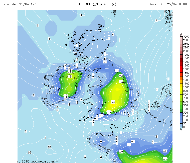
| Hmmm strange, or not, that the GFS is changing so quickly. Here are the 00z runs, for 18:00 Sunday. This seems to be the time when all the figures are at their greatest, so if something does spark off it'll be late afternoon. All fingers are pointing to Wales now, and we DO have a cold front pushing in from the atlantic around the same time. Lapse rates are good, Cape around the high hundreds, LI good, CIN good. Temps are ok. Still a fair way off yet but one to watch. And being as high pressure is already in charge, I can see why NetWeather were onto this too. As we know, times can change, just need those ingredients to keep tallying up. We are only too looking at 50% chance of storms. This is a very valid figure! Confidence is a little low at the moment. All images courtesy of Netweather.tv, and MetOffice UK.         | |
|
| | |
weatherevents.net
Admin

Posts : 152
Hi-Five : 4
Join date : 2010-04-14
Location : Fife, Scotland
| | Subject: Re: UK Weather Forecasts, Reports and Discussion WC 19/04/10 Fri Apr 23, 2010 1:18 am | |
| Well fingers crossed this doesn't fizzle out over the coming GFS runs, but it certainly does seem to keep cropping up, so I reckon there is a reasonable chance of something happening somewhere in the UK on Sunday. Of course, it's more that likely seeing as I'm working nights this weekend and will probably be in my pit if this does all kick off! | |
|
| | |
Updraft
Admin
Posts : 352
Hi-Five : 6
Join date : 2010-04-12
Age : 58
Location : Somerset, UK
| | Subject: Re: UK Weather Forecasts, Reports and Discussion WC 19/04/10 Fri Apr 23, 2010 1:36 am | |
| So yet another huge switch on whats there for Sunday.
Every Run over the past few days has changed dramatically putting and taking away CAPE and LI for fun !
Im not looking properly again until late Fri early Sat now.
Yes there seems to be a chance but hardly confident seeing what GFS has been doing. | |
|
| | |
weatherevents.net
Admin
Posts : 152
Hi-Five : 4
Join date : 2010-04-14
Location : Fife, Scotland
| | Subject: Re: UK Weather Forecasts, Reports and Discussion WC 19/04/10 Fri Apr 23, 2010 2:43 am | |
| 12Z run has just come out.. I can't help myself but look.  Just waiting for the graphs to regen on netweather. | |
|
| | |
Updraft
Admin
Posts : 352
Hi-Five : 6
Join date : 2010-04-12
Age : 58
Location : Somerset, UK
| | Subject: Re: UK Weather Forecasts, Reports and Discussion WC 19/04/10 Fri Apr 23, 2010 4:43 am | |
| Graham i have to admit that ive already been looking again, well you wouldnt expect any different really would you, just cant help myself ! Current Runs looking good...again....just hope they hold together. Im not going to plan anything until ive looked at things Saturday pm i think, go over to High Res NMM then so will get a far more detailed and up to date picture. If things still look favourable then im 99% sure that i will be doing my best out there somewhere and im not going to restrict that to my own back yard either. Time to get out and test what i think i know, if i get it wrong i do, can learn from that as well. Currently showing a large area that may throw up a storm or two although im not thinking we are talking anything major here, may get lucky and catch something if im in the right region ! Talk of Wazza being out there as well so hopefully meet up and see where things lead us, last time didnt happen so maybe this time we will both at least get out the front door Something of note that is worth bearing in mind is that GFS is noted for being overly agressive with Dew Points but more importantly CAPE and LI as well. And nearer the time it generally downgrades to something a little more realistic. Sunday may well follow that pattern. Having read that i think its probably wise to check another Model and look for common ground between them. Will be doing that from now for sure. So all eyes on the Models as usual and lets hope the Storm Season gets going this weekend  | |
|
| | |
weatherevents.net
Admin
Posts : 152
Hi-Five : 4
Join date : 2010-04-14
Location : Fife, Scotland
| | Subject: Re: UK Weather Forecasts, Reports and Discussion WC 19/04/10 Fri Apr 23, 2010 5:44 am | |
| Some good advice there Ups, especially in regards to the GFS being aggressive with it's CAPE and LI figures. I heard that mentioned on another forum as well so I'll be definitely taking those impressive CAPE values with a pinch of salt at the current time. As you say, it's unlikely this setup is going to produce storms of the decade, but if the current values extend without too much downgrading, to the NMM, I definitely think it would be worth heading out, even if it does just turn out to be a learning experience. Unfortunately for me, the closest I'm likely to get to these storms is checking the lighting detectors when I wake up.  But I'll be keeping my fingers crossed for both Wazza and yourself. | |
|
| | |
Updraft
Admin
Posts : 352
Hi-Five : 6
Join date : 2010-04-12
Age : 58
Location : Somerset, UK
| | Subject: Re: UK Weather Forecasts, Reports and Discussion WC 19/04/10 Fri Apr 23, 2010 9:22 am | |
| Nice one Graham, need all the help we can get on most fronts at the moment.
Sunday is looking like it wil throw up a few storms but as you say not looking at anything too exciting maybe. Nearer the time things will become clearer we hope.
Not even able to pick an area at the moment to be honest.
Always looking and hoping here so one day it will work out right im sure. | |
|
| | |
Updraft
Admin
Posts : 352
Hi-Five : 6
Join date : 2010-04-12
Age : 58
Location : Somerset, UK
| | Subject: Re: UK Weather Forecasts, Reports and Discussion WC 19/04/10 Sat Apr 24, 2010 6:28 am | |
| Just a quick update on how things are shaping up for Sunday.
I will leave graphics for now and will definately post something up PM tomorrow when things are set better on NMM models.
The 12z run is still looking favourable for a T/Storm or two over what appears to be a broad area of the UK during the afternoon and early evening. High Pressure is set well at the moment and we have this Cold Front pushing across the UK during Sunday.
There will be some heavy showers, but just how many will turn into T/Storms and of course where ?
Fingers crossed for now and i will get some graphics up as soon as NMM is in range. | |
|
| | |
weatherevents.net
Admin
Posts : 152
Hi-Five : 4
Join date : 2010-04-14
Location : Fife, Scotland
| | Subject: Re: UK Weather Forecasts, Reports and Discussion WC 19/04/10 Sat Apr 24, 2010 7:28 am | |
| As you say Ups, I think the hard bit is going to be picking a target area, with such large areas looking like they have potential. Can't wait to see what the NMM does tomorrow! (Bt guess I'm just going to have to). | |
|
| | |
Updraft
Admin
Posts : 352
Hi-Five : 6
Join date : 2010-04-12
Age : 58
Location : Somerset, UK
| | Subject: Re: UK Weather Forecasts, Reports and Discussion WC 19/04/10 Sat Apr 24, 2010 7:58 am | |
| Get up, go to work , home , GFS/NMM Edit...these bouncy balls are very distracting you know ! | |
|
| | |
Wazza
Admin
Posts : 506
Hi-Five : 4
Join date : 2010-04-12
Age : 41
Location : Milton Keynes, UK
| |
| | |
Sponsored content
| | Subject: Re: UK Weather Forecasts, Reports and Discussion WC 19/04/10 | |
| |
|
| | |
| | UK Weather Forecasts, Reports and Discussion WC 19/04/10 | |
|