Would you like to react to this message? Create an account in a few clicks or log in to continue.


HomeGallerySearchLatest imagesRegisterLog inLatest Topics
Search


Display results as :
 
Rechercher Advanced Search
Weatherevents.net
Netweather.tv
Netweather.tv - Weather forecasts, news and information for the UK
UKASF
UKASF
Met Office Weather
Stormscapes Darwin
SSD
StormScape Photography
SSP
Statistics
We have 46 registered users
The newest registered user is bernerockivf

Our users have posted a total of 1624 messages in 192 subjects


 LIGHTNING IMAGES

Go down 
3 posters
AuthorMessage
pulse1
Moderator
pulse1


Posts : 98
Hi-Five : 2
Join date : 2010-04-12
Age : 62
Location : Darwin, Northern Territory Australia

LIGHTNING IMAGES Empty
PostSubject: LIGHTNING IMAGES   LIGHTNING IMAGES I_icon_minitimeMon Apr 12, 2010 10:55 pm

Got a photo of lightning you captured? Post it here and chat about your experience!

Here's some of mine from the season in Darwin. I use a Canon EOS450D. My lens used on this night was a 24-105mm L series and my settings were around 10-12 secs F5.6- 6.3 and ISO 100.

LIGHTNING IMAGES 12397_358980062356_644862356_3519398_7310273_n

LIGHTNING IMAGES 12397_358980072356_644862356_3519399_8185483_n

LIGHTNING IMAGES 24521_381396247356_644862356_3616672_3885345_n

LIGHTNING IMAGES 24521_381396252356_644862356_3616673_7108725_n
Back to top Go down
http://www.http://StormscapesDarwin.com
pulse1
Moderator
pulse1


Posts : 98
Hi-Five : 2
Join date : 2010-04-12
Age : 62
Location : Darwin, Northern Territory Australia

LIGHTNING IMAGES Empty
PostSubject: Re: LIGHTNING IMAGES   LIGHTNING IMAGES I_icon_minitimeWed Apr 14, 2010 6:37 pm

Inadvertently stuck these images in the wrong thread - doh! all images (c) StormscapesDarwin.com

Massive positive strike - travel is at least 15km vertical.

LIGHTNING IMAGES Mike3

Thunderstorm flickers, hinting at signs of life!

LIGHTNING IMAGES Mike1

Large CG exits the storm and punches through cloud cover.

LIGHTNING IMAGES Mike8

One of my favorite shots - a large positive strike but right in front of me only 6km from me

LIGHTNING IMAGES Mike5

Updrafts are vital for good storm development and maturity, this one is in the early stages but going vertical and a great rate of knots!

LIGHTNING IMAGES Mike4

Extraordinary cloud to ground strikes, note the step leaders feeling their way around at the LHS.

LIGHTNING IMAGES Mike7

Sunset thunderstorm with huge anvil spread - Tiwi Islands

LIGHTNING IMAGES Mike2
Back to top Go down
http://www.http://StormscapesDarwin.com
Wazza
Admin
Wazza


Posts : 506
Hi-Five : 4
Join date : 2010-04-12
Age : 41
Location : Milton Keynes, UK

LIGHTNING IMAGES Empty
PostSubject: Re: LIGHTNING IMAGES   LIGHTNING IMAGES I_icon_minitimeWed Apr 14, 2010 10:31 pm

Beautiful images there Mike, thanks for posting! I hope to get a camera soon enough, need to find £469 quid from somewhere...

I hope to see something like this from our imported storms here from France - Supercell please!

Overtime coming me thinks! Shocked
Back to top Go down
http://www.metweatheruk.net
pulse1
Moderator
pulse1


Posts : 98
Hi-Five : 2
Join date : 2010-04-12
Age : 62
Location : Darwin, Northern Territory Australia

LIGHTNING IMAGES Empty
PostSubject: Re: LIGHTNING IMAGES   LIGHTNING IMAGES I_icon_minitimeFri Apr 30, 2010 12:00 am

Hunting through some old images of lightning and thought you might like to see them...

Lightning from all over Darwin, the rural and inland areas from 2008/9

LIGHTNING IMAGES Index.php?action=dlattach;topic=4358

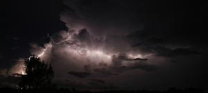
From Mandorah...just me and another chaser alone under the lightning...everyone else was 78km's back in Darwin getting 'little' bolts...whilst we were directly along side the beast!

LIGHTNING IMAGES Index.php?action=dlattach;topic=5029

From Darwin wharf during tea break from work...ISO 200, F8 20 secs

LIGHTNING IMAGES Index.php?action=dlattach;topic=4364

LIGHTNING IMAGES Index.php?action=dlattach;topic=4218

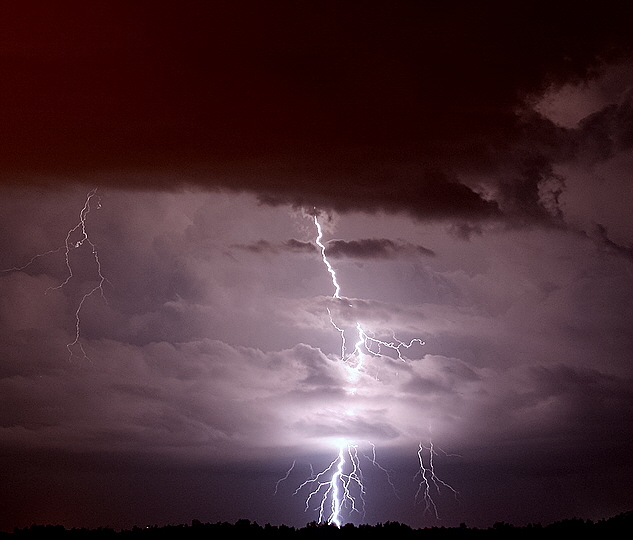
One of my favorites to date...

LIGHTNING IMAGES Index.php?action=dlattach;topic=4357

Some info from 2007/8 wet season...to give you some idea of what type of storms we get that the bureau take note of:

12 Oct Adelaide River OOWA - Multicell complex with 46kt winds.
12 Oct South Alligator River OOWA - Continental squall line 44kt wind gusts.
16 Oct Litchfield OOWA - Pulse severe.
23 Oct Sw of Yulara OOWA - High based splitting cell with right mover persisting.
25 Octo Douglas-Daly OOWA - Multicell with strong updrafts. Overshooting tops visible 90kms away when observed.
31 Oct Kings creek near Watarrka OOWA - Large storm with golf ball hail, damage to helicopter, trees striped of foliage.
1 Nov Alice Springs - Squall line 34 kt winds.
2 Nov Yulara - Cont squall line large hail, gusts to 17kts with 17.4mm falling in half an hour.
3 Nov Alice Springs - Cont squall line, hail.
8 Nov Cox Peninsula - Large cells moved into Darwin.
11 Nov Darwin rural - large storm produced gusts to 60kts, localised flooding and fallen trees.
13 Nov Darwin large cell with 44 kts, Doppler showed 49 kts.
13 November Katherine - Large storm, strong winds, very heavy precip and multiple lightning strikes reported by spotter, fallen trees. Storm came in from the south and intensified as it moved over Katherine.
14 Nov Borroloola - Trough linked from a low over the northern VRD (Victoria River Downs) 50 kts gusts.
15 Nov Palmerston (my home area) Flash flooding from slow moving thunderstorm - 24hr rainfall 289mm total from four nearby areas.
22 Nov Darwin - Multiple cellsfrom the east. SSW issued trees fallen in rural area.
27 Nov Rural area. Strong updrafts SSW issued - trees downed.
6 Dec Darwin - Large scale severe squall line from SE. moving at 35kts, Noonamah 50kts, Darwin 47 kts and 40+ reported at Middle Point. Gates torn off and sail shade torn from poles at suburban public swimming pool.
7 Dec Yulara - Active storms with 50kt wind gusts, reported gale strength winds persisted for more than 20 minutes.
14 Dec far southern Alice Springs - Intense cell north of a squall line (85km east of Giles) moving at 23-30 kts. 2-3 cm hail.
23 Dec Dundee Beach - (this area to the NW of Darwin receive many storms that reintensify once encountering the seabreeze) Storms reformed and an intense echo visible on radar. Weak meso located on Doppler - (an area also renowned for water spouts by the way....)
4 Jan Tiwi Islands - Microburst damage 10-20ha of trees felled in the same direction, little is known about this event.
6 Jan Katherine - two lines of storms moved through the region, second line of storms produced damage to trees.
9 Jan Dundee Beach - Squall line with 30kt gusts, Batchelor reported 40kt gusts.
13 Jan Darwin - thunderstorms produced 211mm of rain.
14 Jan Borroloola - Thunderstorms forming in association with a high pressure ridge and strong westerly winds sharpened a trough through teh Gulf country, storms produced 51kt gusts.
18 Jan VRD - trough moved through inland areas. Gusts to 49kts, pea sized hail, large limbs torn from trees. Most limbs aligned in a west to east direction suggesting microburst. Intense lightning reported by spotter and chook shed blown over, transformer struck.
20 Jan Gulf Ccountry - Strong storms with 60kt gusts.
18 Feb Cox Peninsular/Dundee - line of storms with heavy precip. Monsoon laying south of the Top End. 260.2mm over 24hr period at Cox Peninsular area and gauge overflowed with an extra 40-60mm missed. Charles Point recorded 226.8 for same period (174mm fell in 210minutes!) Dum-in-Marie recorded 308.6mm from 8am-1pm. Several other areas recorded falls over 150mm in 24 hour period.
19 Feb Dundee Beach area - 256mm between 9am - 11:30am.
2 Mar Darwin - Squall line produced flash flooding in Palmerston, boy drowned in flooded culvert. Gusts to 39kts, damaged yacht.
6 March Darwin, rural - Squall line from the SE assocaited with low in the Gulf of Carpentaria.
12 Mar Darwin harbour - Slow moving storms associated with monsoon. rainfall of 191mm at Wagait Beach, 111 at Channel Pt and 96 at Cox Pen.
18 March Batchelor OOWA Gulf line, raifall of 91.2mm in an hour!
22 Mar Darwin and rural - small scale squall line.

Some early thunderstorm shots from 2008

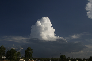
Massive updraft speed with this tower

LIGHTNING IMAGES Index.php?action=dlattach;topic=922

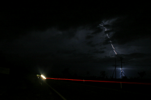
thought I'd lost this one! ISO200 F16 (due to close strikes) at 21 sec exp - hence the trail of the rear lights on the car passing!

LIGHTNING IMAGES Index.php?action=dlattach;topic=922

LIGHTNING IMAGES Index.php?action=dlattach;topic=922

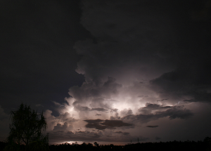
Lightning illuminates the entire storm

LIGHTNING IMAGES Index.php?action=dlattach;topic=922

tree in the way!

LIGHTNING IMAGES Index.php?action=dlattach;topic=922

Large storm forms to the SE of my home area...julian knows this location!

LIGHTNING IMAGES Index.php?action=dlattach;topic=922

ISO200 F10 6 sec exposure

LIGHTNING IMAGES Index.php?action=dlattach;topic=922

more to come...


Last edited by pulse1 on Fri Apr 30, 2010 12:20 am; edited 1 time in total
Back to top Go down
http://www.http://StormscapesDarwin.com
pulse1
Moderator
pulse1


Posts : 98
Hi-Five : 2
Join date : 2010-04-12
Age : 62
Location : Darwin, Northern Territory Australia

LIGHTNING IMAGES Empty
PostSubject: Re: LIGHTNING IMAGES   LIGHTNING IMAGES I_icon_minitimeFri Apr 30, 2010 12:16 am

some more early stuff...many haven't seen these!

LIGHTNING IMAGES ?action=dlattach;attach=3581;image

this one 12 secs, F10 ISO 100

LIGHTNING IMAGES Index.php?action=dlattach;topic=922

Sports mode...1/400 F5 ISO 100

LIGHTNING IMAGES Index.php?action=dlattach;topic=922


ISO 100 F10 15 secs

LIGHTNING IMAGES ?action=dlattach;attach=3635;image

LIGHTNING IMAGES Index.php?action=dlattach;topic=922

birth of a downdraft - not outward spread of condensation in the centre... LIGHTNING IMAGES ?action=dlattach;attach=4179;imagea downdraft.

Moi...hunting...!

LIGHTNING IMAGES ?action=dlattach;attach=4507;image

18 Feb 2009 - it went insane..

LIGHTNING IMAGES ?action=dlattach;attach=6427;image

Beast..simply a beast

LIGHTNING IMAGES Index.php?action=dlattach;topic=4782

massive!

LIGHTNING IMAGES Index.php?action=dlattach;topic=4772

oh well that might do for now...
Back to top Go down
http://www.http://StormscapesDarwin.com
Wazza
Admin
Wazza


Posts : 506
Hi-Five : 4
Join date : 2010-04-12
Age : 41
Location : Milton Keynes, UK

LIGHTNING IMAGES Empty
PostSubject: Re: LIGHTNING IMAGES   LIGHTNING IMAGES I_icon_minitimeFri Apr 30, 2010 3:36 am

Loving those pics Mike. Really crisp, bright, sharp, especially those night ones. Need to do some practising with my cam at night. I have the perfect location, top of a car park overlooking the city, but just need to get out before it closes and locks me in there! Arrow
Back to top Go down
http://www.metweatheruk.net
Joanna762


Posts : 70
Hi-Five : 0
Join date : 2010-04-12
Location : Jersey, UK

LIGHTNING IMAGES Empty
PostSubject: Re: LIGHTNING IMAGES   LIGHTNING IMAGES I_icon_minitimeFri Apr 30, 2010 7:21 am

Mike, those photos REALLY are fantastic! cheers
Back to top Go down
Wazza
Admin
Wazza


Posts : 506
Hi-Five : 4
Join date : 2010-04-12
Age : 41
Location : Milton Keynes, UK

LIGHTNING IMAGES Empty
PostSubject: Re: LIGHTNING IMAGES   LIGHTNING IMAGES I_icon_minitimeWed Nov 24, 2010 10:01 am

I'm just bringing this back to the front as these shots are something I, as well as others aspire too. Very Happy
Back to top Go down
http://www.metweatheruk.net
Sponsored content


LIGHTNING IMAGES Empty
PostSubject: Re: LIGHTNING IMAGES   LIGHTNING IMAGES I_icon_minitime

Back to top Go down
 
LIGHTNING IMAGES
Back to top 
Page 1 of 1
 Similar topics
-
» Daytime storm/weather images
» LIGHTNING - how does it work?
» Darwin lightning at night
» So just how close was this Lightning Bolt then ??
» we going to ely on lightning trackers again this year?

Permissions in this forum:You cannot reply to topics in this forum
 :: Photo/Video Gallery :: Thunderstorms-
Jump to: